Self-development and feedback: A scenario-driven approach by Dr. Tariq Javid Ali Mughal
Abstract: This paper describes how to
organize and use feedback for self-development. The importance of planning and
timely actions to get a realistic feedback is explained by a real world example.
The results derived from a simple feedback form designed in this study are
astonishing as compared to detailed oriented approaches. The scenario based
approach explained in this paper requires a degree of patience and careful
planning to identify areas of improvements. The author believes it is an
innovative milestone towards self-development efforts he was struggling with
sometimes in the past.
Introduction: Self-development is highly desirable
in today’s dynamic world and the needs are undoubtedly higher in the future.
While experience plays an important role in this context, a quicker and well established
method is to obtain feedback from peers having keen interest in your professional
development and career progress. However, the feedback needs to be collected
from as many persons as practically manageable, organized and used
appropriately to get maximum results. The planning is the key to obtain
realistic, honest and fair feedback. Another important and related challenge is
to design a simplified feedback form according to the situation in-hand. The
date and information organized in the form of visuals is more suitable and
convincing than any other form. Identification of areas of improvement is the
primary objective towards formulation of a self-development plan. The execution
of such plan is really beneficial if identification is done in a right manner.
Investments in execution of incorrectly identified areas are less productive
and are therefore potentially harmful in career progress.
Obtaining and Organizing Feedback
Data: The real feedback data was
obtained from a class of seven students. The feedback form was designed
in-advance (Fig.1) and introduced during lecture number four out of total sixteen
lectures. The course was a multidisciplinary postgraduate research level and
all participants were from academic settings include computer engineering,
telecommunication engineering and computer sciences. The printed form was filled
by students after final term paper. The arrangements were carefully planned and
focus was on getting honest feedback from all students. The organization of
data to extract useful information is completed by generating graphs based on
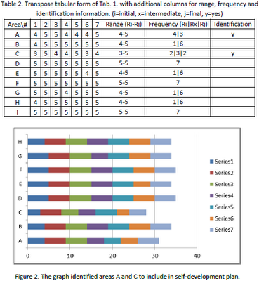
completed feedback forms (Tab.1 and Tab.2). The information organized in graphs
(Fig.2 to Fig.5) clearly indicate areas of improvement, strengths and
importantly build confidence towards better take on similar scenario with
greater control and increase likelihood to achieve difficult targets.
Getting Results: The Tab.2 was constructed as
transpose of Tab.1. The columns were added in steps for rang, frequency and
identification of improvement areas for self-development plan. The areas A and
C were found as must be considered for part of improvement exercise. In
addition areas D and F were identified as strength areas. The overall rating
was found of no use towards self-development plan and therefore discarded in
graph (Fig.2) generation. Figure 2 organized data in clustered bars useful to
identify similar result as in Tab. 2 in a more appealing form. There were
different possibilities explored to arrive at the same conclusion.
Using Results: A time bound execution of
self-development is highly recommended towards maximum gains in a near future
strategy. The results in this study show improvements are required in areas A
and C. There are number of resources that can help to improve these areas. The
main considerations here are cost and time. The pursue decision is most likely
based on set goals and career choices. A possible repeat of similar scenario
and recurrence frequency prediction can help to determine a right timeframe to
complete execution. The improved areas, in this case A and C, ensure success
most likely than left unattended or partially executed. The consequences of
partial execution are topic of a future such paper. The strength areas, in this
case D and F, are considered as ready to use with greater confidence and
control in a similar scenario. This is a big relief and a factor for immediate
count on in this context. Importantly, it requires a sense of situation in-hand
due scenario-driven nature.
Conclusions: The organization of data to
extract useful information towards formulation and execution of a realistic
self-development plan from a practical scenario was described. Use of
simplified feedback form designed according to situation in-hand and carefully
planned approach is highly suggested. A timely execution of such plan increases
success rate for upcoming repeated similar scenarios. The approach used in this
study is straight forward and scenario-driven as compared to experience based
and other time-consuming detailed oriented approaches. The future work focuses
on potential consequences of partial execution of identified self-development
plan.
About Author: Dr. Tariq Javid obtained his PhD
in Electronic Engineering from National University of Sciences &
Technology, Islamabad, Pakistan. He has a rich experience working with IT
systems and security. He is Assistant Professor in Electrical Engineering
Department of Heavy Industries Taxila Education City (HITEC) University, Taxila
Cantt, Pakistan. His research interests include digital image processing,
embedded systems, and information security.

